
Discover the amazing success story redacted by yellowscan about our last project in Temboan, North sulawesi
Continue readingDiscover the amazing success story redacted by yellowscan about our last project in Temboan, North sulawesi
Continue reading
With a great pride and respect, MSDI was invited by the Deputy Governor of Penajam Paser Utara (PPU), Ir.H.Hamdam to discuss a number of programs in the future and the way our system works in a professional manner. With all MSDI representatives in Kalimantan
Continue reading
They speak about us: Yellowscan
Yellowscan, the famous and innovative company which develops the integration of high-end lidar for UAV and market leader, gave us the honor to interview us on a recent project that we carried out in the south west of Borneo (Kalimantan). Yellowscan therefore published this article on their website, highlighting the technical capacities of their solution but also our skills in the conduct of this project, carried out with the aim of providing an exact mapping of 1100 ha for the conversion of an old exploitation of palm oil towards a future coal mine. Here is their article:
Arnaud Denisot is a young IT engineer who decided to change his life. Four years ago, he left his job at La Défense, the Paris-region version of Silicon Valley, and re-established himself with a drone services company headquartered in the seaside town of Sanur, Bali. The new company, Bali Drone Production, gathered steam as a result of its drone and photogrammetry services, but things really took off when Denisot bought his first LiDAR last December, launching with it a new specialized mapping branch of the company called MSDI
“Thanks to the Vx-15,” he says, “we can now be a major player in UAV LiDAR survey services in Indonesia, provide accurate data in correlation with the environmental constraints we encounter here, and intervene quickly on urgent projects.”
Arnaud Denisot
Prior to acquiring the YellowScan Vx-15, Bali Drone Production would fly their Phantom 4Pro or Mavic 2 drones and carry out 3D mapping with ground control points (GCPs) and real time kinematic (RTK) photogrammetry systems. Clearly such equipment would prove insufficient.

The major challenge Denisot faced was one that many surveyors encounter in canopy-heavy Indonesia. “The dense vegetation here and Indonesia’s vast terrain is often rugged and inaccessible. Our technical means and equipment didn’t allow me to provide quality data for my clients,” he says. “I needed to offer new top-of-the-range services to my customers, to extend my range of services and to make my company grow in the industrial field. LiDAR therefore quickly became an obvious choice.”
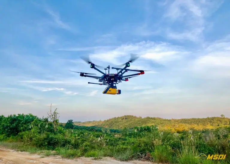
Flying a light-weight drone-mounted LiDAR system that can easily penetrate canopy for efficient 3D mapping enabled Denisot to land his first big job in April, doing a 1,100 hectare survey for a palm oil company. As he points out, “We needed a system that could penetrate the canopy, portable and easy to use to limit the time on the ground and not be cumbersome. Because Indonesia is composed of multiple islands, we are regularly required to take a plane, so the equipment must be compact and respect the recommendations of the airline companies. Finally, we needed a versatile system, able to meet all kinds of demands, even the most demanding as in the field of civil engineering.”
The MSDI job order came in at the 11th-hour, with Denisot having to pick up where another mapping company had failed to complete its mission as a result of a technical mishap. When the competing company could no longer operate their equipment, Arnaud had to come up with LiDAR surveys in order to generate DTMs, contours, and DSMs. The plans would be used to set up a new coal mine to replace the existing palm oil operation. Morever, the client wanted Denisot to capture an average density of 50 points per square meter.
After arranging for the purchase of his YellowScan Vx-15, Arnaud Denisot flew back to France to take a LiDAR crash-course at YellowScan headquarters, just outside the sunny southern city of Montpellier. No sooner had he returned to Bali and got the hang of his new equipment than the phone rang with the client’s last-minute service order. We asked Denisot what for him were the particular benefits of deploying a YellowScan system.
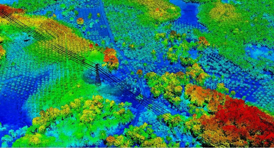
“Certainly for me, the ease of use and the speed of deployment in the field. The LiDAR does not need to be connected to other modules, or external batteries compared to our competitor’s LiDAR. Every flight has been a success, so the system is reliable and durable—we didn’t need to re-fly the mission [to get the point clouds required]. The point clouds are clean and accurate, and our customer was very surprised to see that our data contained no outliner/noise points. The icing on the cake is that the accuracy goes beyond our expectations, as we even had high voltage lines to deal with that were clearly visible, even though the height of the flights was not optimized to achieve such a result, so the customer was pleasantly surprised to have more data than he expected.”
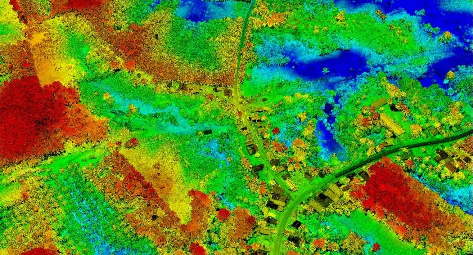
On 8 April, 2020, his company was contracted to map or re-map 1,100 hectares of difficult terrain. Data acquisition took place in just 19 hours, spread over four days in the field. The client’s immediate need was to map 277 hectares by the 15th of April, but with the YellowScan Vx-15, Arnaud found they had already accomplished that first challenge by the morning of the 13th of April, and by the 15th, the entire job was completed.
The competition had averaged only about 50 hectares of surveying per day, at which rate it would have taken them two weeks to survey 1,000 hectares, but MSDI covered 1,100 hectares in 4 days. Flying in drizzling weather, Denisot completed the entire mission in seven morning flights, each day for four days. He found that with the Vx-15 they were able to cover as much as 400 to 500 hectares per day, relying on only seven battery packs and no access to electricity to recharge.
Denisot covered the first zone flying at an altitude of 90 meters, 5m/s, mirror 27hz, while the second zone, which contained more varied terrain, was covered from 80 meters agl, 6m/s, mirror 30hz. To respect the client’s need for point cloud density, the crew flew with a line spacing of 100 meters and the export of the cloud point was done with 110° of FOV. Equipment deployed included the YellowScan Vx-15, with a Matrice 600 Pro drone, 2 sets of TB47 S batteries, 5 sets TB48 S, no camera.
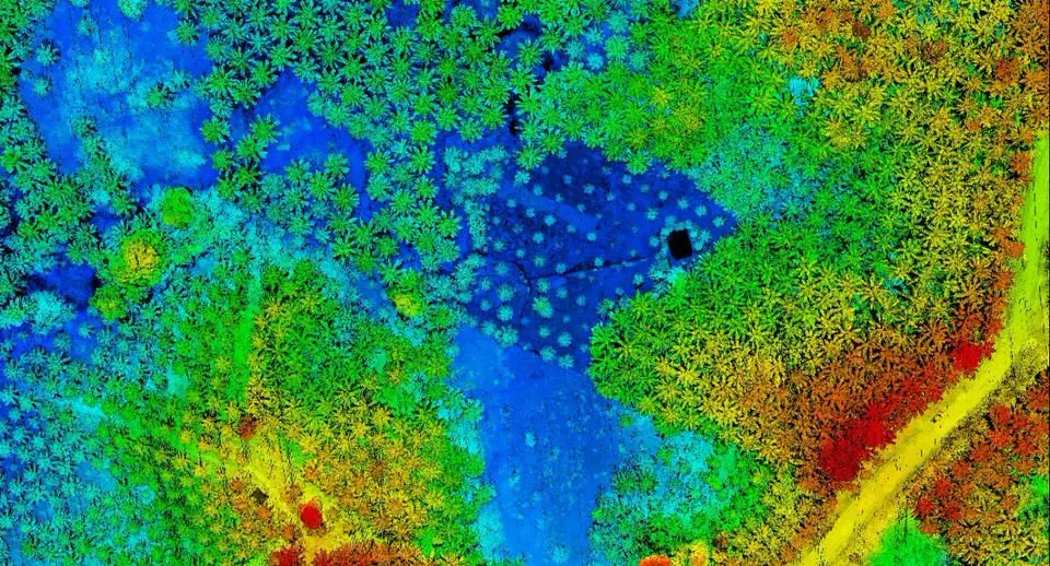
Results included point density averaging from 50 to 60point/m2 – excellent coverage under vegetation. Denisot, who holds both French and Indonesian drone pilot licenses, says that “the LiDAR and software all worked without a hitch.” He underscores the fact that the urgency of this first LiDAR mission was high.
“The stress for this mission was at its peak, because it was a last-minute mission, for a demanding and knowledgeable client, so we had no room for error. Thanks to our Vx-15, we accomplished the mission in record time and the results were beyond our expectations. Our client was surprised by our efficiency and ability to deliver quality data in such a short period of time. Thanks to the Vx-15 we can now be a major player in UAV lidar survey services in Indonesia.”
Arnaud Denisot
– Wrote by Jordan Robert
Special thanks to the yellowscan team for their support and Robert for this article.

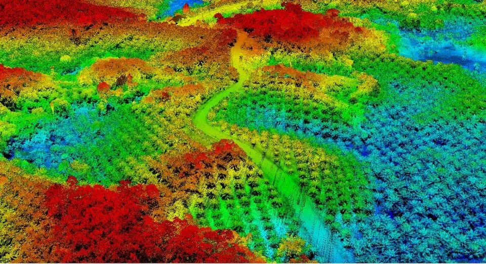
Why we love the lidar systems? Because it makes your job easier !! Look at this map, the algorithm of the software is able to count for you how many trees are present on the map, sort them, and give precise information like height, size, the density of trees on a surface etc… our team will be very happy to work with you on your project so do not hesitate to contact and exchange with us your needs. Our lidar is able to work on forest management, scientific research for the environment, carbon stocktaking, flood analysis and much more…
Contact us to get your personalized quote for your next survey. Https://www.msdi.co.id
#lidar #drone #uav #indonesia #bali #jakarta #kalimantan #3dmapping #survey #topography #yellowscan #vx15 YellowScan #dji #lidarsurveyindonesia #floodanalysis #sciences #forestmanagement #carbonstocktaking RIEGL
Contact us to get your personalized quote for your next survey.
hashtag
#lidar #drone #uav #indonesia #bali #jakarta #kalimantan #3dmapping #survey #topography #yellowscan #vx15 #dji

The power of the LiDAR ! See the invisible! (or uncover the ground from the vegetation;)
One of the most important functionalities of the Lidar is the possibility to pierce the vegetation and measure the ground details. A must-have to get the real shape of the field for your architectural or real estate project. Faster and safer than the conventional survey, the drone lidar mapping services are the solution to your needs. In this video, on the right, we can see the actual environment with all the trees and buildings.
On the left, there is a rendering of the ground without the Vegetation. The LiDAR reveals all the details of the ground which is habitually impossible to see, even by walking, due to the dense vegetation and also because some parts of the land are too dangerous to access.
Contact us to get your personalized quote for your next survey.
hashtag
#lidar #drone #uav #indonesia #bali #jakarta #kalimantan #3dmapping #survey #topography #yellowscan #vx15 #dji

Pol Palacios, a high-level drilling engineer in oil and gas, gave us the privilege to be our Senior board advisor. It is a great pleasure to welcome him among us.

From LinkedIn :
Hi Folks, Yes, no shame. Some time it is good to promote things where we have a vested interest (I’m a non-executive board guy there) and to help young and determined people like Arnaud Denisot. #LocalContent, Oil and Gas. #inspection. Geothermal. Mining. Agriculture. Forestry. Fishing. Natural resources. You name it. Now MSDI is the next stage and you want to use them. Bringing industrial level heavy duty drone services in #Indonesia and beyond with #lidar and full spectrum of #mapping and #3dmapping. Arnaud Denisot has done a phenomenal job over the past years to bring compliant and technological #droneservices to Indonesia where he has been one of the pioneers of the industry with Bali Drone Production. Hashtagging some of my regional network for awareness and wishing Happy New Year to all of them:YellowScan PERTAMINA EP Meri Magdalena Ade Nurhidayat Pungki Ariyanto Russell Morrice Achmad Fahmi Alaydrus Jean-Philippe BERAUD Rifkiandi Darajatun Irawan H Haditomo, STsi, MM Boy Idroos Troy Kiper Conor Egan PT Total Oil Indonesia Thierry BATOT Daniel Bethel Ferdy Serah Andréa ⚡️ Bensaid DJI
https://www.linkedin.com/posts/activity-6616854024471789568-ZYTa
Jl.Tukad Balian No.154B, Denpasar, Bali
Mon–Sat: 09:00–18:00
E-mail : contact@msdi.co.id